DRAINAGE SYSTEM
A river drains the water collected from a specific area, which is called its ‘catchment area’. An area drained by a river and its tributaries is called a drainage basin. The boundary line separating one drainage basin from the other is known as the watershed. The catchments of large rivers are called river basins while those of small rivulets and rills are often referred to as watersheds. There is, however, a slight difference between a river basin and a watershed. Watersheds are small in area while the basins cover larger areas.
the Arabian Sea drainage; and (ii) the Bay of Bengal drainage. They are separated from each other through the Delhi ridge, the Aravalis and the Sahyadris Nearly 77 per cent of the drainage area consisting of the Ganga, the Brahmaputra, the Mahanadi, the Krishna, etc. is oriented towards the Bay of Bengal while 23 per cent comprising the Indus, the Narmada, the Tapi, the Mahi and the Periyar systems discharge their waters in the Arabian Sea.
On the basis of the size of the watershed, the drainage basins of India are grouped into three categories: (i) Major river basins with more than 20,000 sq. km of catchment area. It includes 14 drainage basins such as the Ganga, the Brahmaputra, the Krishna, the Tapi, the Narmada, the Mahi, the Pennar, the Sabarmati, the Barak, etc. (ii) Medium river basins with catchment area between 2,000-20,000 sq. km incorporating 44 river basins such as the Kalindi, the Periyar, the Meghna, etc. (iii) Minor river basins with catchment area of less than 2,000 sq. kminclude fairly good number of rivers flowing in the area of low rainfall. Many rivers have their sources in the Himalayas and discharge their waters either in the Bay of Bengal or in the Arabian Sea.
On the basis of the mode of origin, nature and characteristics, the Indian drainage may also be classified into the Himalayan drainage and the Peninsular drainage.
DRAINAGE SYSTEMS OF INDIA
Indian drainage system consists of a large number of small and big rivers. It is the outcome of the evolutionary process of the three major physiographic units and the nature and characteristics of precipitation.
THE HIMALAYAN DRAINAGE
The Himalayan drainage system has evolved through a long geological history. It mainly includes the Ganga, the Indus and the Brahmaputra river basins. Since these are fed both by melting of snow and precipitation, rivers of this system are perennial. These rivers pass through the giant gorges carved out by the erosional activity carried on simultaneously with the uplift of the Himalayas. Besides deep gorges, these rivers also form V-shaped valleys, rapids and waterfalls in their mountainous course. While entering the plains, they form depositional features like flat valleys, ox-bow lakes, flood plains, braided channels, and deltas near the river mouth. In the Himalayan reaches, the course of these rivers is highly tortous, but over the plains they display a strong meandering tendency and shift their courses frequently. River Kosi, also know as the ‘sorrow of Bihar’, has been notorious for frequently changing its course. The Kosi brings huge quantity of sediments from its upper reaches and deposits it in the plains. The course gets blocked, and consequently, the river changes its course.
EVOLUTION OF THE HIMALAYAN DRAINAGE
Geologists believe that a mighty river called Shiwalik or Indo-Brahma traversed the entire longitudinal extent of the Himalaya from Assam to Punjab and onwards to Sind, and finally discharged into the Gulf of Sind near lower Punjab during the Miocene period some 5-24 million years ago
The remarkable continuity of the Shiwalik and its lacustrine origin and alluvial deposits consisting of sands, silt, clay and boulders. It is opined that in due course of time Indo– Brahma river was dismembered into three main drainage systems: (i) the Indus and its five tributaries in the western part; (ii) the Ganga and its Himalayan tributaries in the central part; and (iii) the stretch of the Brahmaputra in Assam and its Himalayan tributaries in the eastern part. The dismemberment was probably due to the Pleistocene upheaval in the western Himalayas, including the uplift of the Potwar Plateau (Delhi Ridge), which acted as the water divide between the Indus and Ganga drainage systems. Likewise, the down thrusting of the Malda gap area between the Rajmahal hills and the Meghalaya plateau during the mid-pleistocene period, diverted the Ganga and the Brahmaputra systems to flow towards the Bay of Bengal.
THE RIVER SYSTEMS OF THE HIMALAYAN DRAINAGE
The Himalayan drainage consists of several river systems but the following are the major river systems:
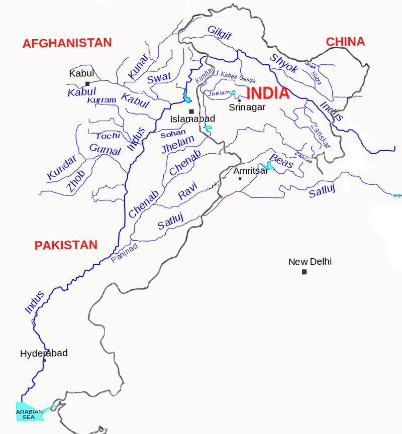
The Indus System
It is one of the largest river basins of the world, covering an area of 11,65,000 sq. km (in India it is 321, 289 sq. km and a total length of 2,880 km (in India 1,114 km). The Indus also known as the Sindhu, is the westernmost of the Himalayan rivers in India. It originates from a glacier near Bokhar Chu (31°15' N latitude and 81°40' E longitude) in the Tibetan region at an altitude of 4,164 m in the Kailash Mountain range. In Tibet, it is known as ‘Singi Khamban; or Lion’s mouth. After flowing in the northwest direction between the Ladakh and Zaskar ranges, it passes through Ladakh and Baltistan. It cuts across the Ladakh range, forming a spectacular gorge near Gilgit in Jammu and Kashmir. It enters into Pakistan near Chillar in the Dardistan region .
The Indus receives a number of Himalayan tributaries such as the Shyok, the Gilgit, the Zaskar, the Hunza, the Nubra, the Shigar, the Gasting and the Dras. It finally emerges out of the hills near Attock where it receives the Kabul river on its right bank. The other important tributaries joining the right bank of the Indus are the Khurram, the Tochi, the Gomal, the Viboa and the Sangar. They all originate in the Sulaiman ranges. The river flows southward and receives ‘Panjnad’ a little above Mithankot
The Panjnad is the name given to the five rivers of Punjab, namely the Satluj, the Beas, the Ravi, the Chenab and the Jhelum. It finally discharges into the Arabian Sea, east of Karachi. The Indus flows in India only through the Leh district in Jammu and Kashmir.
The Jhelum, an important tributary of the Indus, rises from a spring at Verinag situated at the foot of the Pir Panjal in the south-eastern part of the valley of Kashmir. It flows through Srinagar and the Wular lake before entering Pakistan through a deep narrow gorge. It joins the Chenab near Jhang in Pakistan.
The Chenab is the largest tributary of the Indus. It is formed by two streams, the Chandra and the Bhaga, which join at Tandi near Keylong in Himachal Pradesh. Hence, it is also known as Chandrabhaga. The river flows for 1,180 km before entering into Pakistan.
The Ravi is another important tributary of the Indus. It rises west of the Rohtang pass in the Kullu hills of Himachal Pradesh and flows through the Chamba valley of the state. Before entering Pakistan and joining the Chenab near Sarai Sidhu, it drains the area lying between the southeastern part of the Pir Panjal and the Dhauladhar ranges. *Ravi orgintes from Bara Bangal in District Kangra in Himachal Pradesh .
The Beas is another important tributary of the Indus, originating from the Beas Kund near the Rohtang Pass at an elevation of 4,000 m above the mean sea level. The river flows through the Kullu valley and forms gorges at Kati and Largi in the Dhaoladhar range. It enters the Punjab plains where it meets the Satluj near Harike
The Satluj originates in the Rakas lake near Mansarovar at an altitude of 4,555 m in Tibet where it is known as Langchen Khambab. It flows almost parallel to the Indus for about 400 km before entering India, and comes out of a gorge at Rupar. It passes through the Shipki La on the Himalayan ranges and enters the Punjab plains. It is an antecedent river. It is a very important tributary as it feeds the canal system of the Bhakra Nangal project.
The Ganga System
The Ganga is the most important river of India both from the point of view of its basin and cultural significance. It rises in the Gangotri glacier near Gaumukh (3,900 m) in the Uttarkashi district of Uttaranchal. Here, it is known as the Bhagirathi. It cuts through the Central and the Lesser Himalayas in narrow gorges.At Devprayag, the Bhagirathi meets the Alaknanda; hereafter, it is known as the Ganga. The Alaknanda has its source in the Satopanth glacier above Badrinath. The Alaknanda consists of the Dhauli and the Vishnu Ganga which meet at Joshimath or Vishnu Prayag. The other tributaries of Alaknanda such as the Pindar join it at Karna Prayag while Mandakini or Kali Ganga meets it at Rudra Prayag. The Ganga enters the plains at Haridwar. From here, it flows first to the south, then to the south-east and east before splitting into two distributaries, namely the Bhagirathi and the Hugli. The river has a length of 2,525 km. It is shared by Uttaranchal (110 km) and Uttar Pradesh (1,450 km), Bihar (445 km) and West Bengal (520 km). The Ganga basin covers about 8.6 lakh sq. km area in India alone. The Ganga river system is the largest in India having a number of perennial and non-perennial rivers originating in the Himalayas in the north and the Peninsula in the south, respectively. The Son is its major right bank tributary. The important left bank tributaries are the Ramganga, the Gomati, the Ghaghara, the Gandak, the Kosi and the Mahanada. The river finally discharges itself into the Bay of Bengal near the Sagar Island. The Yamuna, the western most and the longest tributary of the Ganga, has its source in the Yamunotri glacier on the western slopes of Banderpunch range (6,316 km). It joins the Ganga at Prayag (Allahabad). It is joined by the Chambal, the Sind, the Betwa and the Ken on its right bank which originates from the Peninsular plateau while the Hindan, the Rind, the Sengar, the Varuna, etc. join it on its left bank. Much of its water feeds the western and eastern Yamuna and the Agra canals for irrigation purposes
The Chambal rises near Mhow in the Malwa plateau of Madhya Pradesh and flows northwards through a gorge up wards of Kota in Rajasthan, where the Gandhisagar dam has been constructed. From Kota, it traverses down to Bundi, Sawai Madhopur and Dholpur, and finally joins the Yamuna. The Chambal is famous for its badland topography called the Chambal ravines
The Gandak comprises two streams, namely Kaligandak and Trishulganga. It rises in the Nepal Himalayas between the Dhaulagiri and Mount Everest and drains the central part of Nepal. It enters the Ganga plain in Champaran district of Bihar and joins the Ganga at Sonpur near Patna
The Ghaghara originates in the glaciers of Mapchachungo. After collecting the waters of its tributaries – Tila, Seti and Beri, it comes out of the mountain, cutting a deep gorge at Shishapani
The river Sarda (Kali or Kali Ganga) joins it in the plain before it finally meets the Ganga at Chhapra
The Kosi is an antecedent river with its source to the north of Mount Everest in Tibet, where its main stream Arun rises. After crossing the Central Himalayas in Nepal, it is joined by the Son Kosi from the West and the Tamur Kosi from the east. It forms Sapt Kosi after uniting with the river Arun.
The Ramganga is comparatively a small river rising in the Garhwal hills near Gairsain. It changes its course to the southwest direction after crossing the Shiwalik and enters into the plains of Uttar Pradesh near Najibabad. Finally, it joins the Ganga near Kannauj.
The Damodar occupies the eastern margins of the Chotanagpur Plateau where it flows through a rift valley and finally joins the Hugli. The Barakar is its main tributary. Once known as the ‘sorrow of Bengal’, the Damodar has been now tamed by the Damodar Valley corporation, a multipurpose project.
The Sarda or Saryu river rises in the Milan glacier in the Nepal Himalayas where it is known as the Goriganga. Along the Indo-Nepal border, it is called Kali or Chauk, where it joins the Ghaghara.
The Mahananda is another important tributary of the Ganga rising in the Darjiling hills. It joins the Ganga as its last left bank tributary in West Bengal.
The Son is a large south bank tributary of the Ganga, originating in the Amarkantak plateau. After forming a series of waterfalls at the edge of the plateau, it reaches Arrah, west of Patna, to join the Ganga.
The Brahmaputra System
The Brahmaputra, one of the largest rivers of the world, has its origin in the Chemayungdung glacier of the Kailash range near the Mansarovar lake. From here, it traverses eastward longitudinally for a distance of nearly 1,200 km in a dry and flat region of southern Tibet, where it is known as the Tsangpo, which means ‘the purifier.’ The Rango Tsangpo is the major right bank tributary of this river in Tibet. It emerges as a turbulent and dynamic river after carving out a deep gorge in the Central Himalayas near Namcha Barwa (7,755 m). The river emerges from the foothills under the name of Siang or Dihang. It enters India west of Sadiya town in Arunachal Pradesh.
Flowing southwest, it receives its main left bank tributaries, viz., Dibang or Sikang and Lohit; thereafter, it is known as the Brahmaputra. The Brahmaputra receives numerous tributaries in its 750 km long journey through the Assam valley. Its major left bank tributaries are the Burhi Dihing, Dhansari (South) and Kalang whereas the important right bank tributaries are the Subansiri, Kameng, Manas and Sankosh. The Subansiri which has its origin in Tibet, is an antecedent river. The Brahmaputra enters into Bangladesh near Dhubri and flows southward. In Bangladesh, the Tista joins it on its right bank from where the river is known as the Yamuna. It finally merges with the river Padma, which falls in the Bay of Bengal. The Brahmaputra is well-known for floods, channel shifting and bank erosion. This is due to the fact that most of its tributaries are large, and bring large quantity of sediments owing to heavy rainfall in its catchment area.
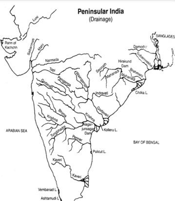
THE PENINSULAR DRAINAGE SYSTEM
The Peninsular drainage system is older than the Himalayan one. This is evident from the broad, largely-graded shallow valleys, and the maturity of the rivers. The Western Ghats running close to the western coast act as the water divide between the major Peninsular rivers, discharging their water in the Bay of Bengal and as small rivulets joining the Arabian Sea. Most of the major Peninsular rivers except Narmada and Tapi flow from west to east. The Chambal, the Sind, the Betwa, the Ken, the Son, originating in the northern part of the Peninsula belong to the Ganga river system. The other major river systems of the Peninsular drainage are – the Mahanadi the Godavari, the Krishna and the Kaveri. Peninsular rivers are characterised by fixed course, absence of meanders and nonperennial flow of water. The Narmada and the Tapi which flow through the rift valley are, however, exceptions
Peninsular Drainage System Evolution
Three major geological events in the distant past have shaped the present drainage systems of Peninsular India: (i) Subsidence of the western flank of the Peninsula leading to its submergence below the sea during the early tertiary period. Generally, it has disturbed the symmetrical plan of the river on either side of the original watershed. (ii) Upheaval of the Himalayas when the northern flank of the Peninsular block was subjected to subsidence and the consequent trough faulting. The Narmada and The Tapi flow in trough faults and fill the original cracks with their detritus materials. Hence, there is a lack of alluvial and deltaic deposits in these rivers. (iii) Slight tilting of the Peninsular block from northwest to the southeastern direction gave orientation to the entire drainage system towards the Bay of Bengal during the same period
River Systems of the Peninsular Drainage
There are a large number of river systems in the Peninsular drainage. A brief account of the major Peninsular river systems is given below :-
The Mahanadi rises near Sihawa in Raipur district of Chhattisgarh and runs through Orissa to discharge its water into the Bay of Bengal. It is 851 km long and its catchment area spreads over 1.42 lakh sq. km. Some navigation is carried on in the lower course of this river. Fifty three per cent of the drainage basin of this river lies in Madhya Pradesh and Chhattisgarh, while 47 per cent lies in Orissa.
The Godavari is the largest Peninsular river system. It is also called the Dakshin Ganga. It rises in the Nasik district of Maharashtra and discharges its water into the Bay of Bengal. Its tributaries run through the states of Maharashtra, Madhya Pradesh, Chhattisgarh, Orissa and Andhra Pradesh. It is 1,465 km long with a catchment area spreading over 3.13 lakh sq. km 49 per cent of this, lies in Maharashtra, 20 per cent in Madhya Pradesh and Chhattisgarh, and the rest in Andhra Pradesh. The Penganga, the Indravati, the Pranhita, and the Manjra are its principal tributaries. The Godavari is subjected to heavy floods in its lower reaches to the south of Polavaram, where it forms a picturesque gorge. It is navigable only in the deltaic stretch. The river after Rajamundri splits into several branches forming a large delta.
The Krishna is the second largest east flowing Peninsular river which rises near Mahabaleshwar in Sahyadri. Its total length is 1,401 km. The Koyna, the Tungbhadra and the Bhima are its major tributaries. Of the total catchment area of the Krishna, 27 per cent lies in Maharashtra, 44 per cent in Karnataka and 29 per cent in Andhra Pradesh.
The Kaveri rises in Brahmagiri hills (1,341m) of Kogadu district in Karnataka. Its length is 800 km and it drains an area of 81,155 sq. km. Since the upper catchment area receives rainfall during the southwest monsoon season (summer) and the lower part during the northeast monsoon season (winter),the river carries water throughout the year with comparatively less fluctuation than the other Peninsular rivers. About 3 per cent of the Kaveri basin falls in Kerala, 41 per cent in Karnataka and 56 per cent in Tamil Nadu. Its important tributaries are the Kabini, the Bhavani and the Amravati.The Narmada originates on the western flank of the Amarkantak plateau at a height of about 1,057 m. Flowing in a rift valley between the Satpura in the south and the Vindhyan range in the north, it forms a picturesque gorge in marble rocks and Dhuandhar waterfall near Jabalpur. After flowing a distance of about 1,312 km, it meets the Arabian sea south of <.strong>Bharuch, forming a broad 27 km long estuary. Its catchment area is about 98,796 sq. km. The Sardar Sarovar Project has been constructed on this river.
The Tapi is the other important westward flowing river. It originates from Multai in the Betul district of Madhya Pradesh. It is 724 km long and drains an area of 65,145 sq. km. Nearly 79 per cent of its basin lies in Maharashtra, 15 per cent in Madhya Pradesh and the remaining 6 per cent in Gujarat.
The Luni is the largest river system of Rajasthan, west of Aravali. It originates near Pushkar in two branches, i.e. the Saraswati and the Sabarmati, which join with each other at Govindgarh. From here, the river comes out of Aravali and is known as Luni. It flows towards the west till Telwara and then takes a southwest direction to join the Rann of Kuchchh. The entire river system is ephemeral.
Smaller Rivers Flowing Towards the West
The rivers flowing towards the Arabian sea have short courses. The Shetruniji is one such river which rises near Dalkahwa in Amreli district.The Bhadra originates near Aniali village in Rajkot district. The Dhadhar rises near Ghantar village in Panchmahal district. Sabarmati and Mahi are the two famous rivers of Gujarat.
The Vaitarna rises from the Trimbak hills in Nasik district at an elevation of 670 m. The Kalinadi rises from Belgaum district and falls in the Karwar Bay. The source of Bedti river lies in Hubli Dharwar and traverses a course of 161 km. The Sharavati is another important river in Karnataka flowing towards the west. The Sharavati originates in Shimoga district of Karnataka and drains a catchment area of 2,209 sq. km. Goa has two important rivers which can be mentioned here. One is Mandovi and the otheris Juari.
Kerala has a narrow coastline. The longest river of Kerala, Bharathapuzha rises near Annamalai hills. It is also known as Ponnani. It drains an area of 5,397 sq. km.The Periyar is the second largest river of Kerala. Its catchment area is 5,243 sq
Small Rivers Flowing towards the East
There are a large number of rivers flowing towards the east along with their tributaries. Some of these rivers. There are small rivers which join the Bay of Bengal, though small, these are important in their own right. The Subarnrekha, the Baitarni, the Brahmani, the Vamsadhara, the Penner, the Palar and the Vaigai are important rivers
Comparison between the Peninsular River and the Himalayan
| Place of origin Peninsular plateau and central highland ,Nature of flow Seasonal; dependent on monsoon rainfall ,Type of drainage Super imposed, rejuvenated resulting in trellis, radial and rectangular patterns , Nature of river Smaller, fixed course with well-adjusted valleys , Catchment area Relatively smaller basin , Age of the river Old rivers with graded profile, and have almost reached their base levels |
| Himalayan mountain covered withglaciers Perennial; receive water from glacier and rainfall Antecedent and consequent leading to dendritic pattern in plains Long courseflowing through the rugged mountains experiencing headward erosion and river capturing; In plains meandering and shifting of course Very large basins Young and youthfulactive and deepening in the valleys |
Highlights of India’s National Water Policy, 2002
The National Water Policy 2002 stipulates water allocation priorities broadly in the following order:
drinking water; irrigation, hydro-power, navigation, industrial and other uses. The policy stipulates progressive new approaches to water management. Key features include:
- Irrigation and multi-purpose projects should invariably include drinking water component, wherever there is no alternative source of drinking water.
- Providing drinking water to all human beings and animals should be the first priority
- Measures should be taken to limit and regulate the exploitation of groundwater
- Both surface and groundwater should be regularly monitored for quality. A phased programme should be undertaken for improving water quality
- The efficiency of utilisation in all the diverse uses of water should be improved
- Awareness of water as a scarce resource should be fostered
- Conservation consciousness should be promoted through education, regulation, incentives and disincentives
In India, the rivers can be divided into two main groups:
- Himalayan Rivers
- Peninsular Rivers
HIMALAYAN RIVERS
- In this three major river systems are there:
The Indus System
- It has a total length of 2880 km (709km in India ). Rises in Tibet (China) near Mansarovar Lake.
- In Jammu and Kashmir, its Himalayan tributaries are: Zanskar, Dras, Gartang, Shyok, Shigar, Nubra, Gilgit, etc.
- Its most important tributaries, which join Indus at various places, are: Jhelum (725km ), Chenab (1800km), Ravi (720 km), Beas (470km)& Sutlej (1050km).
- Sources: Jhelum from Verinag (SE Kashmir), Chenab from Bara Lacha Pass (Lahaul-Spiti, H.P.), Ravi from Kullu Hills near Rohtang Pass in H.P., Beas from a place near Rohtang Pass in H.P. and Satluj from Mansarovar-Rakas lakes in W. Tibet
- In Nari Khorsan province of Tibet, Satluj has created an extraordinary canyon, comparable to the Grand Canyon of Colorado (US).
- According to the Indus Water Treaty signed between India and Pakistan in 1960, India can utilize only 20% of the total discharge of Indus, Jhelum and Chenab.
The Ganga System
- It is 2525 km long of which 1450 km is in Uttarakhand and UP, 445km in Bihar and 520 km in West Bengal
- The Ganga, the head stream is constituted of two main rivers- Bhagirthi and Alaknanda, which combine at Devprayag to form Ganga
- Before Alaknanda meets Bhagirthi at Devprayag, Mandakini meets Alaknanda at Rudraprayag
- Sources: Bhagirthi from Gaumukh, Alaknanda from Badrinath, Mandakini from Kedarnath (all from Uttarakhand).
- Yamuna (1375km) is its most important tributary (on right bank). It rises at the Yamunotri glacier in Uttarakhand. It runs parallel to Ganga for 800km and joins it at Allahabad. Important tributaries of Yamuna are Chambal (1050km), Sind, Betwa (480km) and Ken (all from south).
- Apart from Yamuna, other tributaries of Ganga are Ghaghra (1080km), Son (780km), Gandak (425km), Kosi (730km) Gomti (805km), Damobar (541km). Kosi is infamous as ‘ Sorrow of Bihar’ , while Damodar gets the name ‘Sorrow of Bengal’ as these cause floods in these regions
- Hooghli is a distributory of Ganga flowing through Kolkata
The Brahmaputra system
- It has a total length of 2900 km. it rises in Tibet ( frim Chemayungdung glacier), where it is called Tsangpo, and enters the Indian territory (in Arunachal Pradesh), under the name Dihang.
- Important Tributaries; Subansiri, Kameng, Dhansiri, manas, Teesta
- In Bangladesh, Brahmaputra: is known by the name of Jamuna while Ganga gets the name padma, The ir combined stream is known as padma only. Meghna is the most important distributory before it enters the bay of Bangal
- The combined stream of Ganga and Brahmaputera forms the biggest delta in the world, the sundarbans, covering an area of 58,752 sq. km. its major part is in Bangladesh
- On Bangladesh is river island, Majuli in Asom, the biggest river island in the world
- Brahmaputra, or the Red River,is navigable for a distance of 1384 km up to Dibrugarh and serves as an excellent inland water transport roure.
RIVERS OF THE PENINSULA
- Different from the Himalayan rivers because they are seasonable in their flow (while Himalayan river are perennial.).
- They can be divided into two groups:
A. EAST FLOWING RIVERS (OR DELTA FORMING RIVERS)
- Mahanadi (858 km): Rises in Raipur distt. In Chhatisgarh. Main tributaries; Ib, Seonath, Hasdo, Mand, Jonk, Tel, etc
- Godavari (1465 km): Also called Vriddha Ganga or Dakshina Ganga. It is the longest peninsula river. Rises in Nasik. Main tributaries: Manjra, Penganga, Wardha, Indravati, Wainganga, Sabari, etc
- Krishna (1327 km): Rises in Western Ghats near Mahabaleshwar. Main Tributaries: Koyna, Dudhganga, Panchganga, Malprabha, Ghatprabha, Bhima, Tungabhadra, Musi, etc
- Cauvery (805 km): It is the largest peninsular river (maximum amount of water). Infact, it is the only peninsular river which flows almost throughout the year. It rises from the Brahmagir range of Western Ghats. Main tributaries: Hemavati, Lokpawni, Shimsa. It is less seasonal than others as its upper catchment area receives rainfall during summer by the S.W. monsoon and the lower catchment area during winter season by the retreating N.E. monsoon. Its 90%-95% irrigation and power production potential is already being harnessed.
B. WEST FLOWING RIVERS
- Narmada (1057 km) has only 1/10th part in Gujarat. Rises in Amarkantak Plateau and flows into Guflf of Khambat. It forms the famous Dhuan Dhar Falls near Jabalpur. Main tributaries: Hiran, Burhner, Banjar, Shar, Shakkar, Tawa, etc.
- Tapti (724 km): Rises from Betal distt. In MP. Also known as twin or handmaid of Narmada. Main tributaries: Purna, Betul, Arunavati, Ganjal, etc.
- Sabarmati (416 km): Rises from Aravallis in Rajasthan.
- Mahi (560 km): Rises from Vindhyas in MP
- Luni (450 km): Rises from Aravallis. Also called Salt River, It is finally lost in the marshy grounds at the head of the Rann of Kuchchh.
- Sharavati is a west flowing river of the Sahyadris. It forms the famous Jog or Gersoppa or Mahatma Gandhi Falls (289 m), which is the highest waterfall in India.
INLAND DRAINAGE
Some rivers of India are not able to reach the sea and constitute inland drainage. Ghaggar (494 km) is the most important of such drainage. It is a seasonal stream which rise on the lower slopes of the Himalayas and gets lost in the dry sands of Rajasthan near Hanumangarh. It is consider the old Saraswati of the Vedic times.
Note:
- The largest man made lake in India is Indira Sagar Lake, which is the reservoir of Sardar Sarover Project, Omkareshwar Project and Maheshwari Project in Gujarat MP
- Chilka Lake (Orissa) is the largest brackish water lake of India. Otherwise also, it is the largest lake of India
- Wutar Lake (J&K) is the largest fresh water lake of India. Dul Lake is also there in J&K
- From Sambhar and Didwana Lake (Rajasthan), salt is produced.
- Other important lakes are Vembanad in Kerala and Kolleru & Pulicat in AP.
- The three important Gulfs in the Indian territory are:
- Gulf of Kuchch (west of Gujarat): Region with highest potential of tidal energy generation.
- Gulf of Cambay or Gulf or Khambat (Gujarat): Narmada, Tapti, Mahi and Sabarmati drain into it
- Gulf of Mannar (south east of Tamil Nadu): Asia’s first marine biosphere reserve.
INTER-STATE RIVER WATER DISPUTES IN INDIA
Common Features of the Water Disputes in India
Whatever may be the constitutional scenario applicable to each particular dispute, most disputes seem to have shared the features noted below –
(a) Vagueness regarding the legal doctrine applicable.
(b) Acrimonious tension between the parties.
(c) Overall delay in completion of the adjudication, due to various factors.
(d) Similar other unsatisfactory features.
There is, of course, an occasional silver lining. Some disputes have, for example, been resolved by mutual agreement – even if the parties reached agreement, only after the lapse of a long period
Causes of Inter-state River Water disputes
- River doesn’t follow political limits
- Uneven distribution of water resources
- Increasing Rainfall variability and frequent draughts
- Increasing demand of river water
- Regionalization of the national polity
Some provisions in the British Times
1. Government of India Act, 1919
When dyarchy was introduced in the Provinces (in British India) under the Government of India Act, 1919, irrigation became a Provincial, but “reserved” subject. Before the Provincial Government could take up any project involving the interests of more than one Province, the prior approval of the Secretary of State had to be obtained
2. Government of India Act, 1935
(a) The Government of India Act, 1935 (Provincial List, Entry 19) placed irrigation within the sole jurisdiction of the Provinces.
(b) However, sections 130 to 133 of the Act of 1935 made detailed provisions as to inter-Provincial, etc., disputes concerning water. The relevant provisions applied to “States” also, i.e., to those Indian States, which may ultimately join the contemplated federation. Any Province or State whose interests were perpetually affected in respect of water supplies from a natural source, owing to the action of another Province or State, could complain to the Governor General.
(c) The Governor General was required to appoint a Commission to investigate and report to him on the matters to which the complaint related (unless, in his opinion, the issues were not of sufficient importance).
(d) After consideration of the report, the Governor General was to give such decision as he deemed proper.
(e) The order of the Governor General was to be binding upon the parties. However, before the Governor General gave his decision, the Governor of any State (or the ruler of a Princely State), affected by the order, could require the Governor General to refer the matter to His Majesty in Council, which could give such decision as it deemed proper.
(f) Jurisdiction of the Federal Court (or any other court) was barred, if action to lodge a complaint had been taken by the Governor of a Province, etc
Constitutional Provisions for the Laws applicable to River Water Dispute Settlement
- Entry 17 in the State list makes water a state subject but qualified by Entry 56 in the Union List, which states: “Regulation and development of interstate rivers valleys to the extent to which such regulation and development under the control of the Union is declared by Parliament by law to be expedient in the public interest
- Article 262 (1) of the Indian constitution states that Parliament may by law provide for the adjudication of any dispute of complaint with respect to the use, distribution or control of the waters of, or in, any inter-state river or river valley
- Article 262 (2) of the Indian constitution states that Parliament may by law provide that neither the Supreme Court nor any other court shall exercise jurisdiction in respect of any such dispute
- In short, the whole responsibility of solving water dispute lies with the Parliament
- The River Boards Act, 1956 & the Inter State Water Disputes Act, 1956 have been created for such a purpose
- The Inter State River Water Disputes Act (IRWDA), 1956 is legislation passed under article 262 of the constitution. Section 3 of this act authorizes states to request the Centre to set up a Tribunal if a water dispute has arisen or is likely to arise. Section 4 empowers the Centre to set up a Tribunal if it is of the opinion that the dispute cannot be settled by negotiation. Section 11 of this act states that Supreme Court has no jurisdiction in respect of a water dispute that has been referred to the Tribunal
- The only difference between the Government of India Act, 1935 and the present provisions is that the mandate to set up a Tribunal has been reduced to a discretionary status (i.e. at will & not compulsory).
- Another important provision in the Constitution is Article 39 (b) which mandates the State to direct its policy towards securing that the ownership and control of the material resources of the community are so distributed as best to subserve the common good
The River Boards Act 1956
(a) The River Boards Act, 1956, provides for the establishment of River Boards, for the regulation and development of inter-State rivers and river valleys. On a request received from a State Government or otherwise, the Central Government may establish a Board for “advising the Government interested” in relation to such matters concerning the regulation or development of an inter-State river or river valley (or any specified part) as may be notified by the Central Government.
(b) Different Boards may be established for different inter-State rivers or river valleys.
(c) The Board is to consist of the Chairman and such other members as the Central Government thinks fit to appoint. They must be persons having special knowledge and experience in irrigation, electrical engineering, flood control, navigation, water conservation, soil conservation, administration or finance.
(d) Functions of the Board are set out in detail in section 13 of the Act. Subject-wise, they are very wide, covering conservation of the water resources of the inter-State river, schemes for irrigation and drainage, development of hydroelectric power, schemes for flood control, promotion of navigation, control of soil& erosion and prevention of pollution. But the functions of the Board are advisory and not adjudicatory.
(e) By section 14(3), the Board is directed to consult all the Governments concerned and to secure their agreement, as far as possible.
Thereafter, by section 15, the Board is empowered to frame schemes, obtain comments of the interested Governments and finalise a scheme. [Section 15(4)] But the schemes do not seem to have a mandatory force. It appears from section 15(5) and section 15(6) of the Act that:
(i) the Board can advise the Governments concerned as to execution of the scheme
(ii) the Central Government can “assist the Governments interested”, in taking such steps as may be necessary, for execution of the scheme
Approaches of Resolution
Sub-basin Division Approach:The whole river basin is divided into sub-basins and thereafter the concerned parties are allocated with the command of sub-basin lying within their area.
Principle of Equitable apportionment: The proportionate share of states are decided on the basis of their respective property rights, area of drainage, investments, users and total volume of water in the river
International Law on Settlement of Water Disputes
The International Law commission in its 32nd conference at Helsinki enunciated the four major principles relating to settlement of water disputes. Of these four the Harmon doctrine and the Natural flow theory which conferred absolute rights on the upper and lower riparian (riparian - Of or relating to or located on the banks of a river or stream) respectively, are obsolete. The two relevant theories are:
Equitable Apportionment Theory: This theory envisages the maximum benefit to all riparian states by apportioning water on principles of equity and not equality. Thus, persisting uses by either upper or lower riparian are given due consideration. Doctrine of Prior Appropriation: Article VII of the Helsinki Rules provide that an existing reasonable use may continue in operation unless there are factors which are overwhelmingly against its continuance. Thus, the right to use arises by appropriation and a prior user is given due preference. In effect the prescriptive rights of both riparian’s are protected.
Community of Interest Theory: This theory states that river waters belong to the whole community and must hence be shared equitably to achieve maximum benefit. The underlying premise is that a river is one unit and defies all boundaries.
Other doctrines:
Doctrine rights of Riparian: The doctrine of riparian rights emphasises the recognition of equal rights to the use of water by all owners of land abutting a river, as long as there is no resulting interference with the rights of other riparian owners. The doctrine may not be of much use in the context of inter-State rivers.
Doctrine of prior apportionment: The cardinal rule of the doctrine is, that priority of appropriation gives seniority of rights.
United Nation (UN) and the International Law Commission (ILC)
- In 1970s, UN commissioned the International Law Commission (ILC), a UN body with legal experts nominated by states, to study international law for transboundary water sharing of international water courses. ILC's work resulted in the UN Convention in 1997.
- The UN Convention is yet to come into force since it has not received the minimum 35 number of ratifications
- The Convention gives due importance to both the principles of 'reasonable and equitable utilization' and 'no significant harm.'
- Reasons for reluctance of countries to ratify the convention are not difficult to speculate. These may be the following. First, the highly specific nature of stakes involved in transboundary water sharing makes the states wary of generalized codification of principles. Second, asymmetric politics of upper riparian versus lower riparian states are dialectic and dynamic. Disputes emerge, evolve and recur as sequential response to reciprocities not restricted to just water sharing, but also include the spectrum of issues that impact political relations
- Article 12.1 Equitable Utilization: Basin States shall in their respective territories manage the waters of an international drainage basin in an equitable and reasonable manner having due regard for the obligation not to cause significant harm to other basin States
- Article 16: Avoidance of Transboundary Harm: Basin States, in managing the waters of an international drainage basin, shall refrain from and prevent acts or omissions within their territory that cause significant harm to another basin State having due regard for the right of each basin State to make equitable and reasonable use of the waters
India and the International Laws
- Both the doctrine of prior appropriation and equitable apportionment are applicable here. They have been applied in both the Narmada Water Dispute and the Ravi-Beas Dispute
- The Ravi-Beas Award clearly states that, “…it is now well settled that in deciding water disputes relating to an inter-state river, the rule of equitable apportionment of benefits of a river should be applied
- Both awards extensively quote the Helsinki Rules, 1966 which lay down the guidelines for equitable apportionment.
- Article VII states that past and existing utilization must also be considered to arrive at a solution based on equitable apportionment
Problems with the Inter-State Water Disputes Act of 1956
- States have sometimes refused to accept the decisions of the tribunals. Therefore, arbitration is not binding
- Significantly, the courts have also been ignored on occasion
- Finally, the center has sometimes intervened directly as well, but in the most intractable cases, such as the sharing of the Ravi-Beas waters among Haryana, Jammu and Kashmir, Rajasthan, and Punjab, central intervention, too, has been unsuccessful
- In summary, an unambiguous institutional mechanism for settling interstate water disputes does not exist. Nevertheless, water disputes are sometimes settled. Economic analysis is necessary to illuminate whether and how water disputes get resolved in India
- The Inter-State Water Disputes Act seems to provide fairly clear procedures for handling disputes. At the same time, however, the law permits considerable discretion, and different disputes have followed diverse paths to settlement, or in a few cases, continued disagreement
Current Changes
About IWD (Interstate river Water Dispute) resolution
- Ministry recently announced a plan to create a permanent tribunal for IWD resolution.
- Reasons to create such a tribunal:- 1) The delays in dispute resolution 2) Tendency of the state to approach the Supreme Court for recurring disputes
- The IRWDA (Interstate River Water Disputes Act 1956) provides for setting up a one-time ad hoc tribunal for IWD adjudication. The Act endows the tribunal’s decision with the force of a Supreme Court decree.
- Problems: 1) A permanent tribunal contradicts this intent by providing a permanent space for litigation. The time-frame restrictions may not help much. 2) IWDs are often symptoms of larger interstate relations and have crucial implications for the (re)making of federal democracy. IWD resolution mechanisms should be designed in a changing context of Centre - State and State-State relations.
- On the other hand, due to the bar on its jurisdiction, the Supreme Court cannot engage with disputes beyond providing effect to tribunal awards. States fail to comply with awards, especially when the monsoon fails or due to political compulsions.
- In this changing context of IWD politics, relying entirely on legal remedies, like permanent tribunal, has the danger of leading to extended litigations and antagonistic interstate politics.
- Politicization of IWDs will continue and it is imperative to mitigate the propensity for antagonistic politics between States.
- For this, legal adjudication needs to be supplemented by right institutional interventions: ex-ante for negotiations and agreements, and ex-post for compliance and implementation
Loopholes and solutions of River Water Dispute in India
| Sr. No. | Problems | Solutions |
|---|
| 1 | Property Rights issues | Declaration of water as a national property |
| 2 | Plethora of actors | State government allowed to be the only party |
| 3 | Delays | Setting up of time frame through laws |
| 4 | Enforcement | Commission of an enforcement body |
| 5 | Political Interferences | Experts & judges be member rather than politicians |
Some Other Solutions
- Creation of a quasi-independent hierarchy of institutions. e.g. National Water Dispute Tribunal. Under it there can be Dispute Resolution, Perceptive planning, information gathering, Enforcement and maintenance.
- Drainage basin oriented planning like Damodar Valley Project or Murray Water Commission (Australia)
- Defining priorities of water allocation.
Conclusion
- Any award given by any tribunal must consider the prescriptive rights of any state.
- To develop the machinery for settlement of inter-state river Water disputes, Section 4 of the Act must be amended setting a time frame for constituting the Tribunal by the Centre.
- It must be clearly mentioned in Section 11 of the Act, that the jurisdiction of the courts is barred only for matters already referred to the Tribunal, and the Courts have jurisdiction to order constitution of a tribunal.
- Further, the Tribunal must be made equal to a Court for purpose of enforcing the Award.
- The Judgment of the Supreme Court in recognizing that Article 262 is not a bar to its jurisdiction under Article 131 pr Article 32 has given a new dimension to river water dispute settlement procedures. Thus, the paramount consideration of farmer’s rights has been suitably recognized.
- The policy makers must constitute a National Water Board or any such Central Authority by a statute which will have total control over the use, distribution and control of interstate river waters and specific guidelines must be mentioned for the sharing of waters. Such Authority or Board must also be given the power to take penal action against environmental offenders.
- It must be realized that any use of water must be a planned use, as water is the paramount necessity of a decent life.
The Interstate River Water Disputes Act, 1956 (IRWD Act) is an Act of the Parliament of India enacted under Article 262 of Constitution of India on the eve of reorganization of states on linguistic basis to resolve the water disputes that would arise in the use, control and distribution of an interstate river or river valley. Article 262 of the Indian Constitution provides a role for the Central government in adjudicating conflicts surrounding inter-state rivers that arise among the state/regional governments. This Act further has undergone amendments subsequently and its most recent amendment took place in the year 2002.
River waters use / harnessing is included in states jurisdiction (entry 17 of state list, Schedule 7 of Indian Constitution). However, union government can make laws on regulation and development of inter-State rivers and river valleys when expedient in the public interest (entry 56 of union list, Schedule 7 of Indian Constitution). When public interest is served, President may also establish a interstate council as per Article 263 to inquire and recommend on the dispute that has arisen between the states of India. IRWD Act (section 2c2) validates the previous agreements (if any) among the basin states to harness water of an interstate river/ river valley
Following interstate river water disputes are worth mentioning.
(i) Cauvery water dispute between Tamil Nadu, Karnataka and Kerala.
(ii) The Krishna water dispute between Maharashtra, Karnataka and Andhra Pradesh.
(iii) The Tungabhadra water dispute between Andhra Pradesh and Karnataka.
(iv) The Aliyar and Bhivani river water dispute between Tamil Nadu and Kerala.
(v) The Godavari river water dispute between Andhra Pradesh, Madhya Pradesh, Chhattisgarh, Orissa and Karnataka.
(vi) The Narmada water dispute between Gujarat, Maharashtra, Madhya Pradesh and Rajasthan.
(vii) The Mahi river dispute between Gujarat, Rajasthan and Madhya Pradesh.
(viii) The Ravi and Beas river water dispute between Punjab, Haryana, Himachal Pradesh, Rajasthan, Jammu and Kashmir and Delhi.
(ix) The Satluj-Yamuna Link canal dispute between Punjab, Haryana and Rajasthan.
(x) The Yamuna river water dispute between Uttar Pradesh, Haryana, Himachal Pradesh, Punjab, Rajasthan, Madhya Pradesh and Delhi.
(xi) The Karmanasa river water dispute between Uttar Pradesh and Bihar.(xii) The Barak river water dispute between Assam and Manipur.